Post
Cities: Skylines II Netherlands Pack Official Map Creation Process Sneak Peek
Introducing the Zwolle map creation process, the official Netherlands region pack map for Cities: Skylines II. Provides information on the entire map creation process, including map creation motivation, terrain and waterway design, transportation network configuration, vegetation and detail addition, and resource placement.
1. 🇳🇱 Cities: Skylines II Introducing the Official Netherlands Region Pack Map and Motivation for Creation
- ✅ Introduction to the Zwolle map created to commemorate the release of the new Netherlands Region Pack for Cities: Skylines II
- ✅ Created in collaboration with community members such as Finebold, Jez, Gruni, and Revo
- ✅ Learned about the geography, history, etc. of the Netherlands during the map creation process
- ✅ It is a pity that the implementation of bicycle lanes was delayed, but the map and region pack are designed to allow you to enjoy building Dutch cities.
00:24 - 02:24
1. 🇳🇱 Cities: Skylines II Introducing the Official Netherlands Region Pack Map and Motivation for Creation
- ✅ Introduction to the Zwolle map created to commemorate the release of the new Netherlands Region Pack for Cities: Skylines II
- ✅ Created in collaboration with community members such as Finebold, Jez, Gruni, and Revo
- ✅ Learned about the geography, history, etc. of the Netherlands during the map creation process
- ✅ It is a pity that the implementation of bicycle lanes was delayed, but the map and region pack are designed to allow you to enjoy building Dutch cities.
02:27 - 06:32
2. 📜 History of Zwolle: From Hanseatic League City to Modern City
- ✅ Zwolle is the capital of the province of Overijssel, located in the northeastern Netherlands
- ✅ A strategic point in the Isel River basin, a major trading hub of the Hanseatic League
- ✅ City liberated by the Canadian army during World War II
- ✅ Transformation into a bicycle-friendly city due to citizen movements in response to the increase in child traffic fatalities
- ✅ A city where historical architecture and modern development harmonize
06:33 - 07:19
3. 🚲 Regret for the Lack of Bicycle Lanes and Expectations for Future Updates
- ✅ Expressing regret that bicycle lanes have not yet been implemented in Cities: Skylines II
- ✅ Hoping that bicycle lanes can be added through future updates
- ✅ If bicycle lanes are implemented, you can play as if you are building the Netherlands 50 years ago.
07:20 - 08:26
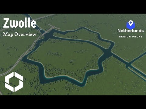
4. 🗺️ Reasons for Choosing Zwolle as a Map: Unique Topography and Historical Background
- ✅ Searching for a new area, excluding existing Dutch maps created in Paradox Mods
- ✅ Exploring interesting areas suitable for 1:1 CS2 maps via Google Earth
- ✅ Fascinated by Canadian Moose's recommendation and Zwolle's unique star-shaped canal system and historical connection with Canada
08:27 - 11:38
5. 🏞️ Terrain and Waterway Design Process: Implementing Folder System and Adjusting Water Flow
- ✅ Placing the star-shaped canal in the center of the map and allowing the Isel River to flow to one corner
- ✅ Modifying the height map to add flat areas, adding embankments and canals, and implementing a folder system
- ✅ The steep appearance of the canal banks is intended to allow players to build quays.
- ✅ Adjusting water flow using 429 water sources
- ✅ Implementing a folder system by building embankments directly
- ✅ The folder system is a unique Dutch land reclamation method of trapping water to create land.
- ✅ It is recommended to build dikes based on river and sea levels and make the buildable area slightly lower.
11:47 - 14:01
6. 🚄 Transportation Network Construction: Reflecting Actual Interchanges and Considering Railway Line Altitude Differences
- ✅ Reflecting actual interchanges (cloverleaf, rotary, trumpet) on the map
- ✅ Utilizing new double-track railway bridges
- ✅ Setting the railway line altitude to 3.75m, taking into account that the tracks of the Dutch train station asset are slightly higher.
- ✅ Includes 4 air connections and 1 sea connection
- ✅ Although sea connections are difficult due to the narrow river, the river width can be widened to create a narrow sea route.
14:07 - 15:46
7. 🌳 Adding Vegetation and Details: Depicting the Characteristics of the Netherlands Region
- ✅ Creating forests using various custom tree brushes
- ✅ Using trees commonly found in the Netherlands (deciduous trees, pine trees), and adding spruce trees to some areas
- ✅ Expressing wetlands or farmland using bush brushes
- ✅ Reflecting the characteristic of not using windbreaks much in farmland
- ✅ You can experience all four seasons, but choose a climate with little snowfall.
- ✅ Adding ruins to the site of pumps or windmills that used to pump water
- ✅ Adding a simple lock between the river and canal
- ✅ Hiding fun Easter eggs (mainly street names) throughout the map
15:47 - 18:04
8. 🗺️ Map Tile and Resource Placement: Farmland, Ore, Oil, Groundwater
- ✅ Map tiles are mainly placed along farmland, rivers, and canals, including the provincial boundary between Overijssel and Gelderland.
- ✅ Fertile land should be placed in the most visible location, but be careful not to make tile maintenance too expensive.
- ✅ Ore is placed mixed with farms or in the hilly forest area to the south.
- ✅ Placing oil resources, taking into account that the Netherlands has onshore gas reserves
- ✅ Groundwater should be placed near water sources where high water levels are expected, but dispersed into small areas to prevent pollution spread.
18:05 - 18:48
9. 🎉 Impressions of Making the 10th Map and Future Plans
- ✅ Feeling moved by making the 10th map for Cities: Skylines 2
- ✅ Thank you to everyone who played the map.
- ✅ The map download link is in the description.
- ✅ Please leave your comments on the map.
- ✅ Considering making an alternative version with less infrastructure and detail
- ✅ Looking forward to seeing what people will build on this map